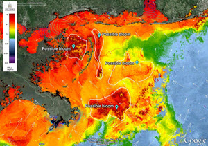
An ocean color satellite imagery from the Visible Infrared Imaging Radiometer Suite coupled with the US Navy’s high resolution circulation models. Researchers used a combination of ocean color satellite products and modeled data to delineate the “possible phytoplankton blooms,” but they need more field work data to confirm these blooms and determine if they are Karenia brevis blooms. (Image credit: Ocean Weather Laboratory)
It’s a catchy name, but the common phrase “Red Tide” for the algal bloom happening right now in the northern Gulf of Mexico is not quite right, scientifically. The bloom is not always red and it’s not always related to tides.
However, the name does invoke a sense of concern about a potential threat to coastal marine life and the public – a threat that has prompted the closing of some beaches and oyster reef harvesting in Alabama, Mississippi, and Louisiana.
Scientists with the Consortium for Oil Spill Exposure Pathways in Coastal River-Dominated Ecosystems (CONCORDE), led by the University of Southern Mississippi, are applying technology that they are using to study the Deepwater Horizon oil spill to monitor this unseasonal algal event. Researchers are using cutting-edge plankton imaging, satellite remote sensing, and modelling technology to track and forecast the bloom’s movement and share their findings with the Mississippi Department of Marine Resources (MDMR).
Most algal blooms are not harmful and provide food for marine animals. However, algal blooms containing high concentrations of the species Karenia brevis can be – its toxin paralyzes the central nervous system of fish so they cannot breathe, causing them to die. Humans potentially can become ill from eating contaminated oysters and other shellfish or experience eye and respiratory irritation as the bloom approaches shorelines.
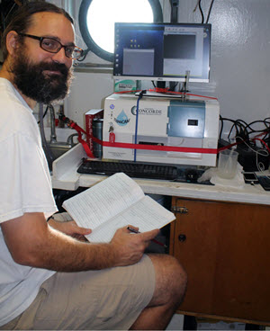
Adam Boyette looks at FlowCAM imagery and makes notes on the organisms that appear. This instrument collects images of all marine microplanktoninc organisms (20-200 micrometers) and can be used to identify certain phytoplankton species. Researchers analyze these images with other parameters such as temperature, salinity, depth, and location which provides researchers a way to monitor marine conditions. (Photo courtesy of CONCORDE)
These phytoplankton are common in the warm, salty waters of South Florida. Scientists first observed this bloom off the coast of Panama City in September 2015, and it has been moving slowly towards Mississippi and Louisiana since then. These phytoplankton populations usually do not thrive in this region; however, the unseasonably warm weather and low rainfall have made conditions ripe for their growth.
Post-doctoral researcher Inia Soto Ramos, an expert on harmful algal blooms, has been monitoring this event for CONCORDE at USM’s Ocean Weather Lab. She explained that the blooms can sometimes change the color of the water when the algae concentration are high, “If you look at the satellite imagery, it’s actually multiple blooms that are spreading out in filaments as they move west.” She continued, “As they move with the currents, some of those filaments break, some disappear, and some grow bigger.”
Soto Ramos and Ph.D. student Adam Boyette are working with the MDMR to track the bloom’s path, confirm the presence of K. brevis, and determine where it will go next. Soto Ramos uses ocean color satellite imagery to identify the bloom’s current locations, then Boyette travels by boat to those sites and analyzes the water using a FlowCAM. The FlowCAM is a flow-cytometer that automatically identifies, counts, images, and analyzes particles such as single-celled organisms in a water sample or from a continuous water flow as it moves through the instrument. Soto Ramos couples information on confirmed identifications of K. brevis with US Navy high-resolution circulation models to estimate where the bloom could go in the next 72 hours.
Boyette reported during recent sampling that the bloom was situated near the southeastern tip of Cat Island, a barrier island south of Gulfport, MS that separates the northern Gulf from the Mississippi Sound. Hydrographic models suggest that this bloom is moving towards the western Mississippi Sound and Breton Sound in Louisiana.
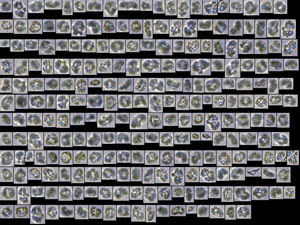
An image collage from the FlowCAM developed from a natural water sample shows a dominance of Karenia brevis with cell concentrations at approximately 7 million cells per liter. (Image by Adam Boyette)
To learn more:
Watch this video that the University of Southern Mississippi produced describing the CONCORDE project and the technology they use in their oil spill research, including the FlowCAM that scientists are using to monitor the Red Tide.
Read this overview of the CONCORDE project: Understanding Oil Transport in Coastal Waters.
Check out the CONCORDE website.
************
This research was made possible in part by a grant from the Gulf of Mexico Research Initiative (GoMRI) to the Consortium for Oil Spill Exposure Pathways in Coastal River-Dominated Ecosystems (CONCORDE).
GoMRI is a 10-year independent research program established to study the effect, and the potential associated impact, of hydrocarbon releases on the environment and public health, as well as to develop improved spill mitigation, oil detection, characterization and remediation technologies. An independent and academic 20-member Research Board makes the funding and research direction decisions to ensure the intellectual quality, effectiveness and academic independence of the GoMRI research. All research data, findings and publications will be made publicly available. The program was established through a $500 million financial commitment from BP. For more information, visit http://gulfresearchinitiative.org.