Researcher Oscar Garcia-Pineda demonstrates some of the methods the team uses to collect imagery and samples of floating oil near MC20. (Provided by Villy Kourafalou)
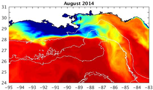
Imagery from the project’s high-resolution Gulf of Mexico model represents sea surface salinity distribution when Mississippi waters extended offshore toward the southern Gulf and interacted with the Loop Current (August 2014). (Provided by Villy Kourafalou)
The flow of the Mississippi River into the northern Gulf of Mexico may have caused circulation patterns and fronts that significantly influenced the transport and fate of Deepwater Horizon oil. However, the Gulf’s complex topography and the proximity of variable oceanic currents to the Mississippi Delta make it difficult to monitor and model these processes.
The Gulf of Mexico Research Initiative recently awarded Dr. Villy Kourafalou a grant to investigate and quantify how river-induced fronts and the circulation patterns they create affect hydrocarbon fate and transport in the presence of complex topography and oceanic circulation patterns, such as the Loop Current. The project seeks to improve the accuracy of hydrocarbon pathway predictions using novel satellite data analyses, field surveys, and data-guided high-resolution physical oceanography and oil spill simulations to target missing knowledge links, particularly oil spreading and thickness under different environmental conditions.
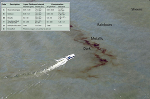
An ASTER satellite image of the project’s May 2016 field campaign and the sampling experiments that targeted areas of different thicknesses. Multiple oil thickness gradients are visible from thin rainbow-sheens to very thick dark-metallic areas of floating oil and emulsions. (Provided by Oscar Garcia-Pineda)
“We want to accommodate this specific oil parameter [oil thickness] that has been challenging to estimate and, therefore, largely missing in oil spill prediction,” said Kourafalou. “We plan to derive a methodology to measure oil spill spreading and thickness and perform comprehensive oil spill simulations that accommodate this additional information.”
The team uses photo-GPS reconnaissance air and boat surveys and optical sensor and synthetic aperture radar data collection to measure the thickness and optical signature of floating oil near a known active leak (Taylor Energy platform, MC20) in the Mississippi River Delta. They conduct their field work during different seasons, environmental conditions, and manifestations of the Mississippi River plume, including low- and high-discharge conditions and interactions with the Loop Current. The researchers will compare field survey measurement to the collected remote sensing data to refine existing algorithms, models, and maps of Deepwater Horizon footprint and surface oil thickness.
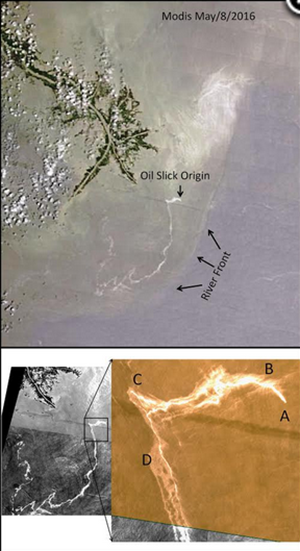
Satellite images based on MODIS (top) and ASTER (bottom) high-resolution satellite data collected May 8, 2016. (Provided by Chuanmin Hu and Oscar Garcia-Pineda)
The researchers will re-simulate Gulf of Mexico conditions from 2008-2017 using their high-resolution Gulf of Mexico Hybrid Coordinate Ocean Model (GoM-HYCOM), which includes mesoscale Gulf processes and fronts and filaments associated with the Mississippi River plume dynamics. These simulations will help the team carefully study the interactions between Mississippi River and Loop Current frontal dynamics and quantify their influence on hydrocarbon transport, particularly when the Loop Current exports Mississippi River waters southward.
Using their observations of oil thickness and spread, the team will initialize an oil spill simulation for the Deepwater Horizon incident period with more detailed oil slick properties and forcing data. After validating the simulation with satellite data products and available Deepwater Horizon data, the team will investigate how ocean currents and other features, especially river-induced fronts, influenced the surface spreading of Deepwater Horizon oil. Repeated simulations will examine the oil’s transport behavior under various environmental and circulation conditions.
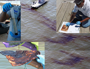
Researchers analyze and measure samples collected from the MC20 site to characterize oil thickness. (Provided by Oscar Garcia-Pineda)
The researchers believe that an improved understanding of coastal, shelf-break, and deep-sea interactions could have important implications for oil spill science and for resource management and disaster response. “Oil exploration often takes place off wetlands and rivers, where released hydrocarbons become subject to river-induced currents and fronts,” said Kourafalou. “Understanding how these factors influence oil pathways will help improve the predictions of oil spill models and guide response and recovery efforts.”
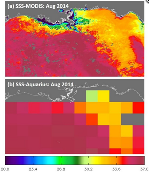
Imagery of sea surface salinity for a period when Mississippi waters extended offshore toward the southern Gulf of Mexico due to interactions with the Loop Current (August 2014). A special algorithm derived salinity from the ocean color MODIS satellite data (top), which provides substantially improved resolution of features compared to the available salinity imagery from Aquarius satellite data (bottom). (Provided by Chuanmin Hu)
The team is producing outreach products that engage both local coastal communities and the international science community, including middle-school science class materials designed to motivate student career paths in STEM fields and “science made easy” videos distributed through social media.
The project’s researchers are Villy Kourafalou at the University of Miami, Oscar Garcia-Pineda at Water Mapping, LLC, Lars Robert Hole at the Norwegian Meteorological Institute, and Chaunmin Hu at the University of South Florida. Their project is Influence of River-Induced Fronts on Hydrocarbon Transport.
************
The Gulf of Mexico Research Initiative (GoMRI) is a 10-year independent research program established to study the effect, and the potential associated impact, of hydrocarbon releases on the environment and public health, as well as to develop improved spill mitigation, oil detection, characterization and remediation technologies. An independent and academic 20-member Research Board makes the funding and research direction decisions to ensure the intellectual quality, effectiveness and academic independence of the GoMRI research. All research data, findings and publications will be made publicly available. The program was established through a $500 million financial commitment from BP. For more information, visit http://gulfresearchinitiative.org/.