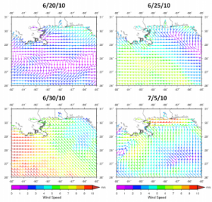
Wind data depicting the weather conditions during a period of interest beginning with typically weak summertime winds associated with a high pressure ridge (top left), then winds off of Mississippi becoming easterly associated first with a developing Tropical Storm Alex off of Yucatan, followed by fringe effects of category 2 Hurricane Alex as it approaches Mexico (lower left), concluding with an offshore cold front in the eastern Gulf (not shown) in which a non-tropical low forms on the front’s western end and circulates south of Louisiana (lower right). Image/DISL
The Deepwater Horizon oil spill alone presented a potentially devastating environmental and economic threat to the northern Gulf of Mexico region. Unfortunately, an additional threat loomed as the summer of 2010 marched on and hurricane season became more active. In late June and early July, the oil that had remained offshore for the most part, began washing up on beaches and salt marshes from Louisiana to Florida. Scientists at Mississippi State University (MSU) largely attribute this inundation of oil to two strong weather systems and are developing models to help predict where and how oil moves in light of such climatic conditions.
Classroom Activity: Hurricane Tracking
Hurricanes, known by scientists as tropical cyclones, are extreme meteorological events. They can bring strong winds, heavy rain, cause widespread flooding and even spawn tornadoes. In this activity students will learn about tropical cyclones, how and where they develop, and plot one using historical data.
Influence of Weather and Ocean Currents in Predicting Oil Movement After Deepwater Horizon – PDF 1MB
