CONCORDE studies sub-surface exposure pathways
 After the Deepwater Horizon incident, the coastline oiling that occurred raised questions about oil movement and impact. For example, before a surface slick reached land, was there oil below the surface waters and how might that affect coastal environments and organisms?
The Gulf of Mexico Research Initiative recently awarded CONCORDE a grant to study nearshore currents and circulation flows and their potential role in creating sub-surface oil exposure pathways.
CONCORDE is the acronym for the CONsortium for oil spill exposure pathways in COastal River-Dominated Ecosystems. Director Monty Graham with the University of Southern Mississippi shared some thoughts about their consortium’s project that will examine the circulation of particle-rich waters in river-dominated areas:
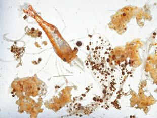
The complex circulation that exists on surface nearshore waters may also exist underneath the surface, providing oil exposure pathways to organisms such as plankton and fish and crustacean larvae that live close to shore. We will analyze the transition area where freshwater from inlets meet salt water from further off shore.
Their study area includes the bird-foot delta, the part of Louisiana where the Mississippi River empties into the Gulf of Mexico, eastward to the Alabama/Florida border, and southward close to the continental shelf break.
Likening the nearshore environment to a layered cake, Graham said that waters come into the Gulf from multiple sources, creating below-surface water masses of varying temperatures and salinities that move like rivers traveling horizontally at different depths. CONCORDE investigators will conduct experiments at “unprecedented scales” that will contribute to high-resolution modeling of these fine-scale variabilities in their coastal study area. Graham described the centimeter-scale resolution as a defining niche or distinct aspect of their research that will account for coastal circulation affected by river input:
Data collected from shallow water columns are often very “noisy”. But, high biomass and plankton concentrations can be very important at these scales. If concentrations of plankton are layered with oil-associated particles, they could be exposure hot spots. To know where those hot spots are, you have to get into the physics at this extraordinary detail.
The team will investigate the physical, geochemical, and biological processes from the river to the open Gulf. Analyses of these processes will improve knowledge about the vertical distribution of sub-surface water flow that could transport oil and other pollutants into highly productive coastal waters and estuaries. The group’s research will have applications beyond oil spill science, as Graham explained:
Understanding coastal river-dominated waters and their complex circulations will help us learn about larvae movement into and out of the sound and passes. We’ll learn about water exchange nearshore to offshore, which will help us better understand the physical processes driving hypoxia, nutrient dynamics, and populations of important natural resources.
The team will have several data-collection efforts over the next three years, including the AUV Jubilee held a few weeks ago, a two-vessel expedition in October, and another expedition next spring.
Chemical tracers will help scientists identify waters that are coming from the shelf, rivers, and ground water sources. There will be two modeling components – one to help the team conduct adaptive sampling during field campaigns and another that will create a four-dimensional synthesis model to identify potential exposure pathways. This model will be portable to future spill scenarios impacting similar river-dominated coastal ecosystems.
The AUV Jubilee was a collaborative data collection event that will help scientists understand more about variable coastal processes and help determine the scales at which they need to sample. Autonomous Underwater Vehicles (AUVs) collected physical data and identified patterns of sediment and phytoplankton distribution. Other data collection methods included in situ moorings, surface vehicles, remote sensing, and aerial surveys. Data collected will be integrated in theNational Glider Data Assembly Center.
During the fifteen-day October field campaign, the team will travel in three main corridors – the Mississippi Sound, Mobile Bay, and east of Mobile Bay – from nearshore to off shore, capturing different freshwater outflow magnitudes. Graham described the Deep-focus Plankton Imager (DPI) that they will use:
This high-resolution laser scans and builds a continuous image as it moves through the water. We will used it from the shelf to the shore, painting a picture of the whole water column to understand the horizontal and vertical variability of microscopic plankton.
CONCORDE’s outreach efforts emphasize building public trust in science, something that Graham explained as being “near and dear to my heart.” He described his experiences during the oil spill in 2010:
I’ve always thought that most people considered scientists as trustworthy, like firemen and policemen. During the oil spill, there was a lot of skepticism about what was being said. Some people began casting others as ‘one of us’ or ‘one of them.’ Some considered scientists using BP research funds as ‘one of them’ and did not trust our work. I have made my career as an unbiased scientist providing research for the good of this region. So the relationship between the public, science, and trust became a very interesting and personal issue for me.
The team has planned teacher professional development, interactions with commercial fishing communities, and public seminars to help build public trust in science.
There will be a social science component to explore the role of culture, seeking input from local Vietnamese, Croatian, and African American communities about their views of science. Then, the team will invite these communities to engage in the scientific process. Graham described the reasoning behind their outreach efforts:
It’s unraveling what people think about science and how it can be applied. We’re involving people from local communities in our missions so that the science resonates with them. By getting instruments in their hands and engaging them in our activities, hopefully they will find that science is not mysterious and they can contribute to it.
Graham anticipates that lessons learned from their outreach will help scientists be more effective in public interactions the next time an incident like an oil spill happens:
We want the public to approach science with a sense of trust. This is particularly important to communities that work on the coast and rely on its resources – that they will consider research findings as reliable for issues such as seafood and beach safety.
The CONCORDE team includes the University of Southern Mississippi (lead institution), Dauphin Island Sea Laboratory, Mississippi State University, the Naval Research Laboratory, Old Dominion University, Oregon State University, and Rutgers University.
For more information about the CONCORDE program and people involved, click hereand visit the CONCORDE website.
Other GoMRI efforts that complement CONCORDE include the Sea Grant Oil Spill Outreach Program working to make connections and build trust among coastal residents and industries, as well as the CARTHE Surfzone Coastal Oil Pathways Experiment in Florida researching complex near coastal currents.