A team of scientists and education staff developed a user-friendly curriculum to help students make connections between the theoretical nature of science and real world applications.
This education tool uses application-based science conducted by the Deep-C Consortium to improve Gulf of Mexico literacy and addresses issues such as environmental disasters, their impacts on ocean ecosystems, and nature’s recovery mechanisms.
The materials and lesson plans contained in this 144-page book align with Ocean Literacy Principles and Florida’s Next Generation Sunshine State Standards. The curriculum has five modules, each representing the main research areas of the Deep-C Consortium: geomorphology, geochemistry, ecology, physical oceanography, and modeling. Each module includes five cumulative lessons, background information on the topic, relevant supplementary reading materials, a glossary, and an assessment.
For a downloadable PDF version of the curriculum, click here. For more information, click here.
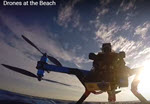
The Gulf of Mexico Research Initiative congratulates the CARTHE research team for their first place award-winning video that teaches Drone Technology for Oil Spill Research.
Over 37,000 middle school students across twenty-one countries selected the winning ocean science research videos after a two-month evaluation of the top entries that best explained scientific results and significance.
The Florida Center for Ocean Science Education Excellence (sponsor) and the National Science Foundation (funder) established the Ocean 180 Video Challenge to provide scientists a platform and an opportunity to translate research importance and outcomes to non-experts.
CARTHE’s winning video demonstrates the use of drones during their SCOPE experiment to understand how nearshore currents move contaminants in the water. One of the contest requirements was to have an accompanying peer-reviewed journal article, which the CARTHE team published in the 2015 American Meteorological Society Surf zone monitoring using rotary wing Unmanned Aerial Vehicles.
Graduate student Patrick Rynne, a member of the CARTHE video creation team, explained that the ability to communicate scientific findings is an essential skill to develop. “Although it is critical that research goes through the peer-review process, we also have a responsibility to deliver our findings in a digestible way to the public.”
Teacher Kathryn Blysma, whose students at Dr. John Long Middle School in Wesley Chapel, FL participated as judges applauded this effort to connect classroom lessons and scientific discoveries. “Too often, students only see science in isolation with the benchmarks assigned to them, rather than the real-world application of that learning,” said Blysma. “Making connections between classroom learning and the real-world is critical to being good stewards of our planet.”
The winning video was a collaborative effort that included University of Miami RSMAS graduate students and creators of Waterlust, Patrick Rynne and Fiona Graham; scientists Ronald Brouwer, Ad Reniers, and Matthieu de Schipper with Delft University; Jamie MacMahan with the Naval Postgraduate School, and CARTHE Outreach Manager Laura Bracken. Read more…
Credits: Patrick Rynne and Fiona Graham, Waterlust. Music: The Submarines – 1940 (AmpLive Remix) Instrumental. Filmed with GoPro Hero 3+ cameras
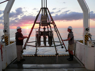
Researchers prepare to deploy a multi-corer which will collect sediment samples from the sea floor. Photo: USM
Initially, much of the oil released from the Macondo well during the Deepwater Horizon disaster floated on the surface of the water. Over time, physical processes drove some of the oil onto beaches and into other shallow habitats of the northern Gulf of Mexico. Researchers from the University of Southern Mississippi are trying to determine where the rest of the oil went. They want to see if oil has also reached the sea floor at greater depths, and if so, where.
Classroom Activity: Deep-Sea Sediments
The ocean floor is made up of sediment including sand, silt and clay particles. The skeletons of tiny animals also contribute to deep-sea sediments. The particles take different amounts of time to reach the sea floor, depending on their density and size. Scientists study the layers of particles to create a historical record of the ocean floor. In this lesson, students will examine a core sample and conduct an experiment to see what factors influence settling rates.
Data collection points, used to track oil, along the Mobile Bay Ship Channel. Figure credit: DISL
During the Deepwater Horizon oil spill, the potential for oil to be distributed into and around Mobile Bay was unknown. The movement and redistribution of dissolved or very small particles of oil-based substances remained a concern long after the well was capped. Consequently, NGI researchers at the Dauphin Island Sea Lab quickly began sampling the bay to document the presence of oil and to determine what forces affected oil movement in the bay.
Classroom Activity: Oceanography to Limnology
Scientists use a variety of techniques to gather information about aquatic habitats. Whether it be Mobile Bay, the Gulf of Mexico, a creek or pond, scientists use similar methods for analyzing the physical and chemical properties of a body of water. Monitoring water quality is important in determining the health of an ecosystem and for identifying potential problems such as pollution.