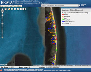
A SCAT map of a portion of the Chandeleur Islands which are the focus of ACER’ research. Credit: https://gomex.erma.noaa.gov/erma.html
A Shoreline Cleanup and Assessment Technique (SCAT) map indicates the degree of oiling at a geographic location. SCAT teams survey shorelines to collect important data that will help them analyze the amount of necessary cleanup, choose cleanup techniques, and monitor clean up effectiveness.