Author Archives: Suzanne Shean

Class Project: Responses of Benthic Communities to Oil Exposure

Researchers prepare to deploy a multi-corer which will collect sediment samples from the sea floor.

Researchers prepare to deploy a multi-corer which will collect sediment samples from the sea floor. Photo: USM

Initially, much of the oil released from the Macondo well during the Deepwater Horizon disaster floated on the surface of the water. Over time, physical processes drove some of the oil onto beaches and into other shallow habitats of the northern Gulf of Mexico. Researchers from the University of Southern Mississippi are trying to determine where the rest of the oil went. They want to see if oil has also reached the sea floor at greater depths, and if so, where.

Classroom Activity: Deep-Sea Sediments
The ocean floor is made up of sediment including sand, silt and clay particles. The skeletons of tiny animals also contribute to deep-sea sediments. The particles take different amounts of time to reach the sea floor, depending on their density and size. Scientists study the layers of particles to create a historical record of the ocean floor. In this lesson, students will examine a core sample and conduct an experiment to see what factors influence settling rates.

Responses of Benthic Communities to Oil Exposure – PDF 1.1MB

Class Project: Residents and Visitors of Mobile Bay – Oil Spill Impacts

Researchers measure the health of a Florida manatee captured in Mobile Bay, AL before fitting it with a satellite tag.

Researchers measure the health of a Florida manatee captured in Mobile Bay, AL before fitting it with a satellite tag. Photo credit: DISL

In Mobile Bay, two key species were at risk for contamination as oil entered the surrounding waters after the Deepwater Horizon disaster; the commercially important eastern oyster and the endangered West Indian manatee. These very different species were closely monitored to study effects of oil exposure not only because of their special interest throughout the northern Gulf, but because they represent two distinct habitat niches and life-styles typical of species in local waters (stationary bottom-dwelling residents and mobile ocean-going visitors).

Classroom Activity: Migrating Manatees
Some animals stay in one general area their entire life while others migrate, sometimes very long distances. Animals may migrate to another area to mate, find food, because of a change of season or other environmental or behavioral cues. Florida manatees spend the winter in Florida near the warmth of springs that remain at a constant temperature year round but during the warmer months travel long distances in search of aquatic plants to eat. In the US they travel as far west as Texas and as far north as Virginia.

Residents and Visitors of Mobile Bay_Oil Spill Impacts – PDF 1.4MB

Class Project: Phytoplankton and the Oil Spill

L to R: Diatom Ditylum brightwelli, dinoflagellate Heterocapsa triquetra (Images/LSU) and a dramatic example of a red tide event (Image/NOAA).

L to R: Diatom Ditylum brightwelli, dinoflagellate Heterocapsa triquetra (Images/LSU) and a dramatic example of a red tide event (Image/NOAA).

The Deepwater Horizon disaster exposed countless plants and animals to harmful crude oil. Though less visible, phytoplankton were also impacted. Scientists from Louisiana State University are investigating what effects the toxic components of crude oil may have on phytoplankton by studying two common species of the Gulf of Mexico.

Classroom Activity: Phytoplankton
What is a phytoplankton bloom? Why do they happen? In this activity students will learn about phytoplankton, blooms, why they can be dangerous and how human activity may play a role in the frequency of blooms.

Phytoplankton and the Oil Spill – PDF 1.5MB

Class Project: Monitoring Nursery Habitats After the Oil Spill

Researchers use a specially designed net to trap animals that use the marsh during high tide.

Researchers use a specially designed net to trap animals that use the marsh during high tide. Credit: Ryan Moody

Salt marshes and seagrass meadows, common across the northern Gulf of Mexico, are highly productive ecosystems that provide critical habitat to many ecologically and economically important species of finfish and shellfish. Juvenile crabs, shrimp and fish that seek refuge in these habitats were threatened during the Deepwater Horizon disaster. Fortunately, scientists are finding no significant changes in Alabama’s marsh and seagrass habitats.

Classroom Activity: Random Sampling
Random sampling methods are used by scientists to estimate species abundance or species diversity in a given area. These methods can easily be adapted for classroom or at-home activities.

Monitoring Nursery Habitats After the Oil Spill – PDF 1.6MB

Class Project: Monitoring Gulf Coast Fisheries

Researchers conduct longline surveys, sampling red snapper and other fish, to monitor oil spill impacts.

Researchers conduct longline surveys, sampling red snapper and other fish, to monitor oil spill impacts. Photo credit: DISL

Following the Deepwater Horizon oil spill disaster, NGI funded researchers increased the frequency and expanded the coverage of monthly sampling programs across the northern Gulf of Mexico. Data collected by Dauphin Island Sea Lab scientists after the oil spill, is being compared to historical baseline data, allowing for the potential identification of changes in the structure of these critical populations.

Classroom Activity: Mark and Recapture
Mark and recapture is a sampling technique scientists use to estimate population size. A simplified version of the mark and recapture method used in fisheries research can be done as a classroom activity.

Monitoring Gulf Coast Fisheries – PDF 1.2MB

Class Project: Mobile Bay Ship Channel – Tracking the Oil

Data collection points, used to track oil, along the Mobile Bay Ship Channel.

Data collection points, used to track oil, along the Mobile Bay Ship Channel. Figure credit: DISL

During the Deepwater Horizon oil spill, the potential for oil to be distributed into and around Mobile Bay was unknown. The movement and redistribution of dissolved or very small particles of oil-based substances remained a concern long after the well was capped. Consequently, NGI researchers at the Dauphin Island Sea Lab quickly began sampling the bay to document the presence of oil and to determine what forces affected oil movement in the bay.

Classroom Activity: Oceanography to Limnology
Scientists use a variety of techniques to gather information about aquatic habitats. Whether it be Mobile Bay, the Gulf of Mexico, a creek or pond, scientists use similar methods for analyzing the physical and chemical properties of a body of water. Monitoring water quality is important in determining the health of an ecosystem and for identifying potential problems such as pollution.

Mobile Bay Ship Channel_Tracking the Oil – 800KB

Class Project: Microbes and the Marine Food Web

A flow cytometer is used to analyze bacteria, archaea and viruses collected after the oil spill.

A flow cytometer is used to analyze bacteria, archaea and viruses collected after the oil spill. Photo credit: DISL

Scientists across the Gulf of Mexico, with support from NGI, are evaluating the impacts of the Deepwater Horizon oil spill on the health of the marine ecosystem. To understand the effects on key elements of the marine food web, one Dauphin Island Sea Lab scientist is comparing microbial samples taken before the oil spill to samples that were exposed to Deepwater Horizon oil.

Classroom Activity: Food Web Wipeout
Food webs demonstrate complex feeding relationships among species in an ecosystem by combining several food chains. Scientists use food webs to demonstrate the fragile and interconnected nature of an ecosystem. This activity demonstrated the complexity of a food web and what can happen when one component of a food web is altered.

Microbes and the Marine Food Web – PDF 1.1MB

Class Project: Influence of Weather and Ocean Currents in Predicting Oil Movement After Deepwater Horizon

Wind data

Wind data depicting the weather conditions during a period of interest beginning with typically weak summertime winds associated with a high pressure ridge (top left), then winds off of Mississippi becoming easterly associated first with a developing Tropical Storm Alex off of Yucatan, followed by fringe effects of category 2 Hurricane Alex as it approaches Mexico (lower left), concluding with an offshore cold front in the eastern Gulf (not shown) in which a non-tropical low forms on the front’s western end and circulates south of Louisiana (lower right). Image/DISL

The Deepwater Horizon oil spill alone presented a potentially devastating environmental and economic threat to the northern Gulf of Mexico region. Unfortunately, an additional threat loomed as the summer of 2010 marched on and hurricane season became more active. In late June and early July, the oil that had remained offshore for the most part, began washing up on beaches and salt marshes from Louisiana to Florida. Scientists at Mississippi State University (MSU) largely attribute this inundation of oil to two strong weather systems and are developing models to help predict where and how oil moves in light of such climatic conditions.

Classroom Activity: Hurricane Tracking
Hurricanes, known by scientists as tropical cyclones, are extreme meteorological events. They can bring strong winds, heavy rain, cause widespread flooding and even spawn tornadoes. In this activity students will learn about tropical cyclones, how and where they develop, and plot one using historical data.

Influence of Weather and Ocean Currents in Predicting Oil Movement After Deepwater Horizon – PDF 1MB

Class Project: Impacts of Oil on Spotted Seatrout

Oil and water mixture used in exposure experiment on larval and juvenile spotted seatrout.

Oil and water mixture used in exposure experiment on larval and juvenile spotted seatrout. Photo/Griffitt USM

Call them spotted seatrout, speckled trout, or even specks; whatever name you choose to call them, know they are important fish, both to the environment and the economy. Spotted seatrout live in coastal estuaries of the northern Gulf of Mexico. They, along with other estuarine species, were exposed to varying amounts of oil soon after the Deepwater Horizon disaster. Since the spill, researchers at the University of Southern Mississippi’s Gulf Coast Research Lab (GCRL) Toxicology Research Center have been trying to better understand what physical effects the oil and chemical dispersants may have had on these important fish.

Classroom Activity: How old is that fish?
Did you know scientists can tell how old a fish is by looking at its otoliths or “earstones” and counting the rings? Similar to tree rings, fish otoliths have layers that can be counted to determine age. In this activity, students will learn what otoliths are, why they are important to a fish and how scientists can study them to learn more about the life of a fish. Students can also play an interactive game to examine otoliths and age fish.

Impacts of Oil on Spotted Seatrout – PDF 1MB

Class Project: Gulf of Mexico Beaches and Dunes – Oil Spill Impacts

Oil layer uncovered on Pensacola Beach, FL

Oil layer uncovered on Pensacola Beach, FL. Photo credit: Huettel FSU

Shortly after the explosion of the Deepwater Horizon rig, oil began washing ashore on many Gulf coast beaches. Over time, because of wind and waves, oil was buried below the beach surface. The impact of oil on sandy habitats, beach dwelling animals and water quality has not been well studied; therefore, scientists at Florida State University are researching what effect the buried oil is having on the beach and dune environments that have been impacted across the northern Gulf of Mexico.

Classroom Activity: Barrier Islands
Barrier islands are dynamic habitats that support many uniquely adapted plants and animals. In this lesson, students will learn about the characteristics of beaches, dunes and other barrier island habitats, the forces that drive them and how they were made vulnerable during the oil spill.

Gulf of Mexico Beaches and Dunes_Oil Spill Impacts – PDF 1MB

Class Project: Gulf Coast Salt Marshes – Oil Spill Impacts

Satellite image of 2010 sampling locations along Louisiana and Mississippi coast

Satellite image of 2010 sampling locations along Louisiana and Mississippi coast. Image credit: MSU

The Deepwater Horizon oil spill put hundreds of miles of the northern Gulf of Mexico coastline in harm’s way. Salt marshes in Louisiana, Mississippi and Alabama received varied amounts of oil during the summer of 2010, ranging from light sheen and tarballs in the east to patchy, heavy oiling in the west and along barrier islands. Dr. Deepak Mishra, along with colleagues at Mississippi State University, is working with NGI to address the large scale disturbances of these fragile gulf coast salt marshes.

Classroom Activity: Photosynthesis
Photosynthesis, the process by which plants take carbon dioxide from the atmosphere, add water, and use the energy from sunlight to produce sugar, can be divided into two major reaction types: light-dependent and light-independent. This activity demonstrates both, and can lead to further discussions and experiments of factors in the environment that can affect the rate of photosynthesis.

Gulf Coast Salt Marshes_Oil Spill Impacts – PDF 1.4MB

Class Project: Florida to Louisiana: Tracing the Oil

Florida to Louisiana_Tracing the Oil

This map shows the radiocarbon content of sediments on the seafloor of the Gulf. The more bright colors represent less radiocarbon; indicative of oil input. You can clearly see the trace of the oil plume to the southwest of the spill site (marked with an x). Image credit: Jeff Chanton, FSU

The effects of the Deepwater Horizon oil spill on the ecology of the Gulf of Mexico are, for the most part, still unknown. Florida State University has developed an integrated study of the impact of oil on the coastal and ocean marine ecosystem of the Gulf of Mexico, including the northern West Florida Shelf, extending from the Big Bend Region west to Louisiana. They are investigating the effects of the spill on coastal ecosystems with a particular emphasis on changes in the food webs that support major commercial and recreational fisheries in the Gulf and in locating oil on the seafloor.

Classroom Activity: You Are What You Eat
Students will investigate a food chain and explore how what an animal eats and where it lives leaves permanent chemical marks on them. The chemical marks can be analyzed by scientists and allow them to learn about the animals life history.

Florida to Louisiana_Tracing the Oil – PDF 1.2MB

Class Project: Fish Health and Oil Exposure

Dr. Edelmann’s laboratory assistants use a mass spectrometer to analyze protein samples. Photo credit: MSU

Dr. Edelmann’s laboratory assistants use a mass spectrometer to analyze protein samples. Photo credit: MSU

In the past, oil exposure has been associated with devastating infectious disease outbreaks in wild populations of fish. The links between these outbreaks and the oil exposure are circumstantial but they suggest an associated disruption of the immune system. Scientists at Mississippi State University hope to use state-of-the art laboratory techniques to determine if the Deepwater Horizon oil spill is affecting the health of fish populations in the Gulf of Mexico.

Classroom Activity: The Immune System
The immune system is made up of special cells, proteins, tissues and organs designed to protect our bodies from invading bacteria, microbes, viruses, toxins and even parasites. In most cases, the body’s immune system does a good job of preventing infection. But sometimes stressors can result in a weakened immune system. NGI scientists are examining how oil exposure may be affecting the immune response of several species of fish.

Fish Health and Oil Exposure – PDF 1.2MB

Class Project: Ecosystem Modeling Framework

An Integrated Ecosystem Assessment incorporates human, biotic, and physical interactions of an ecosystem that result from human and natural system disturbance. Image Credit: DISL

An Integrated Ecosystem Assessment incorporates human, biotic, and physical interactions of an ecosystem that result from human and natural system disturbance. Image Credit: DISL

For several years now, a team of scientists from research institutions across the Gulf coast has worked together to develop an Integrated Ecosystem Assessment (IEA) model for the northern Gulf of Mexico. Researchers, including oceanographers, ecosystem modelers, and population ecologists came together shortly after the Deepwater Horizon oil spill to set up the framework for examining the ecological impacts of the disaster.

Classroom Activity: Ecosystems
Scientists study ecosystems by learning about their living and non-living components and how they are connected to one another. In this lesson, students will discover what an ecosystem is and explore one, either in person or virtually, to better understand all of the components.

Ecosystem Modeling Framework – PDF 1MB

Class Project: Deep-Sea Red Crabs

Live deep-sea red crab collected by Dr. Harriet Perry to study effects of the oil spill. Photo: Belinda Serata/NWF

Live deep-sea red crab collected by Dr. Harriet Perry to study effects of the oil spill. Photo: Belinda Serata/NWF

Many of us are familiar with coastal habitats, like salt marshes and seagrass beds, the services they provide, and the seafood they produce. Unfortunately, the deep sea doesn’t have this type of exposure and is often misunderstood. Scientists from the University of Southern Mississippi (USM) are hoping to change that. They are studying this foreign land, and the animals that inhabit it, to determine the short- and long-term ecological impacts of the Deepwater Horizon oil spill.

Classroom Activity: Exploring the Deep Sea
The deep sea is home to fascinating, yet largely unexplored communities of organisms. As a result, the importance of these ecosystems is relatively unknown. In this lesson, students will learn about deep-sea habitats, the organisms that live there and what adaptations allow them to survive in such extreme conditions.

Deep-Sea Red Crabs – PDF 1.0MB

Class Project: An Overview of the Deepwater Horizon Oil Spill

Satellite image of the Gulf of Mexico showing the spreading oil sheen May 24, 2010. (Photo/NASA)

Satellite image of the Gulf of Mexico showing the spreading oil sheen May 24, 2010. (Photo/NASA)

On April 20, 2010, the Deepwater Horizon oil rig exploded off the coast of Louisiana. The resulting oil spill lasted 87 days and created the largest accidental release of oil the world had ever seen. While much of the northern Gulf of Mexico was spared, receiving little to no oil, other areas were heavily impacted. Several different methods were used to contain and clean up the oil, with varied success. Efforts to remove oil from the water and beaches are onging where necessary. Scientists continue to monitor coastal habitats to document and understand both the short- and long-term effects.

Classroom Activity: Still the Spill
Protecting the estuaries and coastal habitats of the northern Gulf of Mexico was of utmost importance during the Deepwater Horizon oil spill. A variety of materials were used to protect habitats and clean up the oil as it came ashore. Dispersants, chemicals that break down hydrocarbons, were used in some locations.

An Overview of the Deepwater Horizon Oil Spill – PDF 1.4MB

Class Project: Coastal Alabama and Mississippi Fish Communities

DISL sampling sites in coastal Mississippi and Alabama. Image credit: DISL

DISL sampling sites in coastal Mississippi and Alabama. Image credit: DISL

The explosion of the Deepwater Horizon oil rig was of extreme concern to research scientists, environmental managers, and conservationists. Because of public health concerns, state and federal authorities quickly closed many areas of the northern Gulf of Mexico to recreational and commercial fishing. NGI researchers at the Dauphin Island Sea Lab immediately began studying the oil spill including what effect the closures and subsequent lack of fishing pressure had on fish populations.

Classroom Activity: Marine Protected Areas
During the oil spill, fishing bans created a temporary sanctuary (similar to a Marine Protected Area) across a large portion of the northern Gulf of Mexico. Marine Protected Areas (MPAs) are environments that have been reserved by federal, state, territorial, tribal, or local laws or regulations to provide lasting protection for part or all of the natural and cultural resources contained within. The level of protection varies from site to site depending on the desired management and conservation strategies. Information about the National MPA system can be found at http://marineprotectedareas.noaa.gov/nationalsystem.

Coastal Alabama and Mississippi Fish Communities – PDF 1.1MB

Class Project: Chemical Effects of the Oil Spill: Mississippi Sound

Researcers deploy a water sampling device to measure conductivity, temperature and depth (CTD) at different points of the water column. Photo credit: Alan Shiller USM

Researcers deploy a water sampling device to measure conductivity, temperature and depth (CTD) at different points of the water column. Photo credit: Alan Shiller USM

Since the explosion of the Deepwater Horizon oil rig, scientists from a variety of backgrounds have been hard at work collecting samples to monitor the effects of the oil on marine environments. Dr. Alan Shiller, a chemical oceanographer from the University of Southern Mississippi (USM), has been studying both direct and indirect chemical effects from the spill. Direct effects include the spread of crude oil and the physical and chemical changes of the oil over time while indirect effects pertain to changes in natural ocean processes. This includes the prevention of exchange of oxygen at the surface of the water because of the presence of an oil slick. His observations provide other oil spill researchers with valuable information in seeking to understand ecosystem effects of the oil spill.

Classroom Activity: Oil-Munching Microbes
Oil, from natural seeps in the ocean floor, continuously flows into the environment. Some microbes, including bacteria, are specially adapted to survive exposure to hydrocarbons and are even able to use it as food. In this lesson, students will learn about natural oil seeps, the Gulf of Mexico oil spill, and how microbes are helping clean up our environment. An experiment may be added to this lesson so students can observe and evaluate the effectiveness of oil-eating microbes.

Chemical Effects of the Oil Spill Mississippi Sound –  PDF 866KB

Boaters, Vacationers, and Beach Lovers Report Drift Cards for Oil-Spill Research

2130a

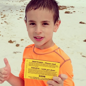
A young boy found a driftcard while swimming at Santa Rosa beach, FL. His mother sent this message, “What a fun surprise since my husband and I are both former aggies….Our son loved it!!” (Photo courtesy of Amber C and GISR)

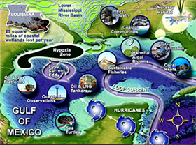
Summer fun check list: 1. enjoy the sun, sand, and surf along the beautiful Gulf of Mexico; 2. track ocean currents; and 3. win a prize.

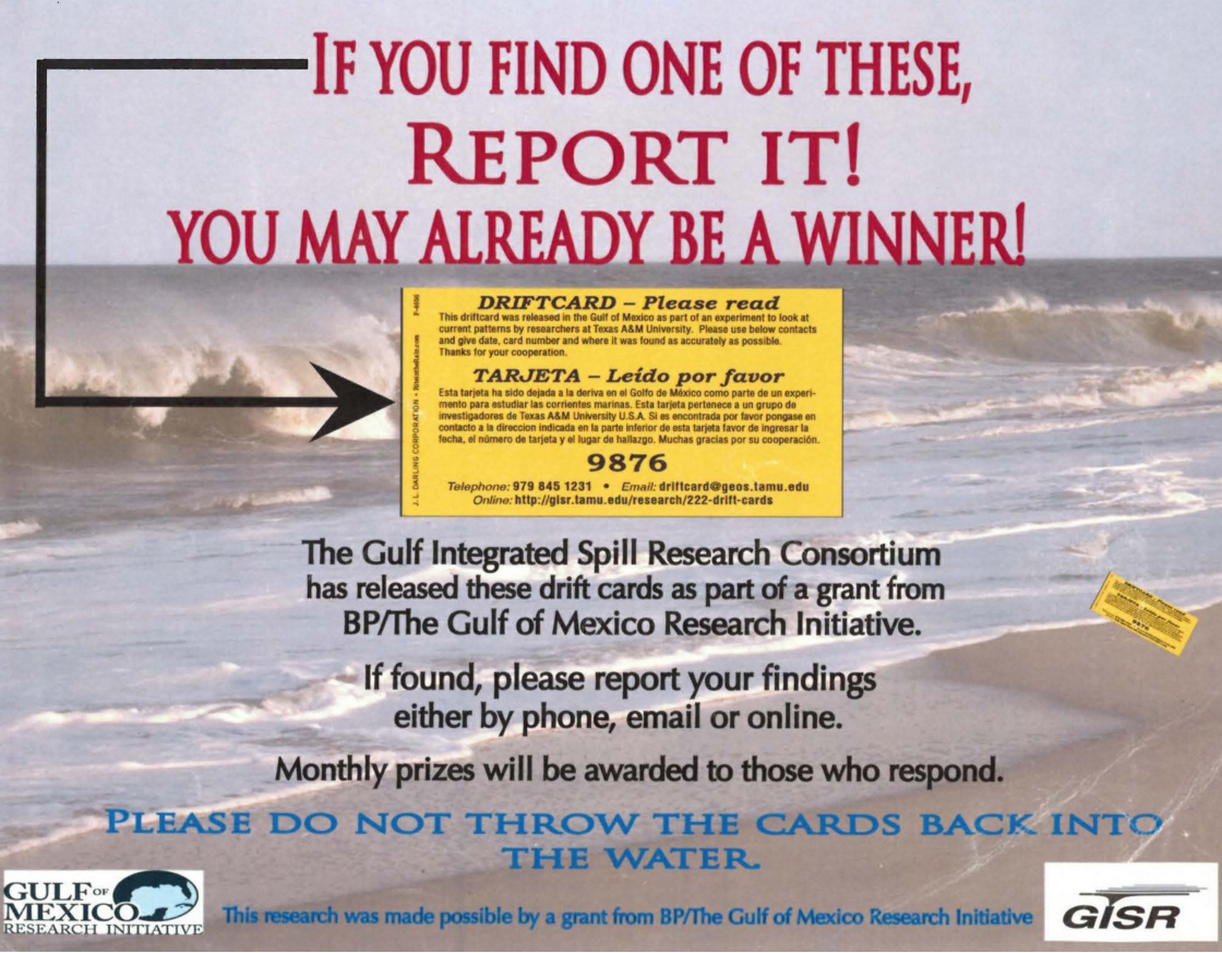
Track ocean currents? Win a prize? Yes! Adults and children from Florida to Texas are calling, emailing, and going online to report little yellow cards they find in the water and on the beach. The locations of these cards give scientists important information for an ongoing study to aid future oil spill response. The data are important enough to be prize-worthy and the public’s participation in science is getting regional media attention.

It happened just like that for Patricia and her husband from Ohio, vacationing in Panama City Beach, FL, one of their favorite summertime spots. They spotted a bright yellow card floating on the water. After looking at it, they realized it was not trash but rather part of a scientific study to track Gulf currents. They followed the instructions on the card to report its location and they won the first $25 gift card.

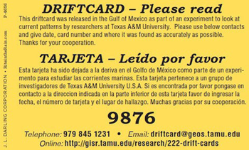
Scientists took great care in manufacturer specifications to make the drift cards environmentally friendly, not adding to ocean trash or toxins. Manufacturers used biodegradable mahogany wood, making the break down process similar to what happens naturally when tree limbs fall into water. They used non-toxic paint that does not contain Tributyltin (TBT) and sealed the print using a UV process, not solvents.   The cards have an estimated water-floating life of about three to six months, depending on sea conditions and interactions with sand and rocks. Instructions on the drift cards are in English and Spanish.

2130b

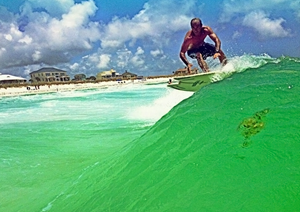
The 2nd driftcard prize recipient, Lance M., builds surfboards in Florida and sent this picture. He was surfing when he found his driftcard. (Photo courtesy of Lance and GISR)

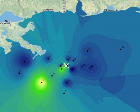
The Gulf Integrated Spill Research (GISR) consortium is using the cards as part of a larger research effort to understand how wind and currents move items on surface waters. Using field and laboratory experiments, scientists with GISR are working to improve prediction models in the event of another oil spill. Dr. Piers Chapman at the Texas A&M University (TAMU) leads the GISR consortium that consists of ten research institutions across six U.S. states and Britain. Volunteer researchers will release 5,000 drift cards from vessels located across the Gulf. Click here for an interactive map that shows up-to-date drifter card deployment and landing sites.

The deployment and recovery data from the drift cards will go into a particle tracking model – the Larval TRANSport Lagrangian model (LTRANS). Lagrangian models help scientists understand the many factors which influence the hidden pathways along which air and water flow. Elizabeth North at the University of Maryland runs the LTRANS code working to develop more realistic particle tracking capabilities. Other GISR project scientists are working to develop a nested wellhead-to-beach Gulf circulation model against which the drift card data will be compared. In addition, Drs. Rob Hetland and Kristen Thyng (TAMU) have developed a web-based particle tracking tool that will aid such comparisons.

2130c

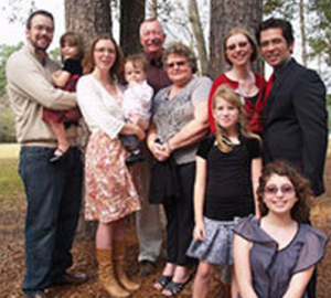
Tollie, and his wife, Peggy, were celebrating their 43rd wedding anniversary on the beaches of Bolivar Peninsula in Texas when they found a driftcard. They were the 3rd gift card recipients. (Photo courtesy of Tollie and GISR)

Dr. Joseph Kuehl at TAMU explains that GISR will compare the data from the cards to computational models of Gulf currents, “It will be interesting to compare the drift card observations to numerical particle trajectories, since the drift cards will be influenced by the wind and waves like a surface slick.  It is impractical to expect accurate 1-1 comparisons between the model trajectories and drift cards.  Instead, we will look for differences in larger scale ocean features between numerical trajectories, drift cards, and satellite data. The shelf break tends to be a barrier to transport, acting to isolate the coastal zone from the open ocean.  Perhaps, we will find that drift cards do not see the same transport barriers that we are used to thinking about.”

The first 1,250 drift cards released elicited more than 200 responses. In previous drift card studies he was involved with, Chapman reported a two percent response rate. If reporting continues at current levels, the response may climb to twenty percent. This increased rate is likely due to a combination of the encapsulating nature of the Gulf’s coastline (as compared to previous open ocean drift card releases) and high public and media interest in the Gulf oil spill. The first card was found by Rebecca in Pensacola Beach, FL. That same day another was recovered by David in Alabama. These reports came only four days after the first set of cards had been deployed!

2130d

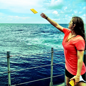
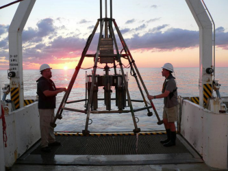
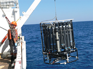
Laura Harred, on a NOAA Mechanisms Controlling Hypoxia cruise, releases driftcards. The Chief Scientist for this cruise was Dr. S.F. DiMarco. (Photo courtesy Ruth Mullins-Perry and GISR)

“Drift cards are deployed in groups of ten, so it is interesting to look at how they spread.  Cards deployed within a few feet of each other can end up miles apart,” says Kuehl.

The Gulf of Mexico attracts many visitors in the summer, increasing opportunities for people from different places to find and report drift cards.  For example, Matt and his fiancé came to coastal Alabama to get married and found three cards in two days. Veli and her son from Finland were vacationing in Corpus Christi, TX, and found a card on a crowded beach. Alvaro, an educator, was leading a group of youngsters near the Texas Padre Island National Seashore when they found a card. Kelly, also a teacher, found her card at Crystal Beach and said she cannot wait to share the story with her students when school resumes. Kim and Mike found six cards while fishing off the Louisiana coast – the most cards found in a single day.

And the prizes? Each month, the research team sends a $25 gift card to a person randomly-selected by a computer from names of people who report a card. Everyone who submits drift card information is eligible for the drawing. While the money is a nice incentive, helping scientists better understand Gulf currents makes this a win for everyone who lives, works, and plays along the Gulf of Mexico. The drift card program will continue until reports stops.

The GISR consortium wishes to thank the many universities and research organizations who have voluntarily distributed the drift cards at sea and help make this program a success.

For more information, go to the GISR website. Additional articles include Scientists Seek Public Help in Oil Spill Research and Sun, Surf, and Drift Cards: The Summer of 2013 on The Gulf of Mexico.

This research was made possible in part by a Grant from BP/The Gulf of Mexico Research Initiative (GoMRI) through the Gulf Integrated Spill Research (GISR) Consortium. The GoMRI is a 10-year, $500 million independent research program established by an agreement between BP and the Gulf of Mexico Alliance to study the effects of the Deepwater Horizon incident and the potential associated impact of this and similar incidents on the environment and public health.

Scientists Seek Public Help in Oil Spill Research

2122a

GISR Drift Card Poster
(Click to enlarge)

You may already be a winner! That is what folks will read on posters across the Gulf region if they find and report bright yellow cards drifting in Gulf waters or washed up on beaches.  This small biodegradable card is part of a larger research effort to better understand Gulf currents and improve future oil spill response.

This summer, scientists on research cruises, funded by the Gulf of Mexico Research Initiative (GoMRI), will drop these cards at various locations in the Gulf and keep a detailed record of the point of entry.  Each card has a unique number and instructions for the public to call or email the card number and describe where they found it. To encourage public participation, people who report the location of cards they find will be eligible for a $25 gift card as thanks for their efforts.

Dr. Piers Chapman at Texas A & M University is the Director of the GoMRI-funded Gulf Integrated Spill Research Consortium (GISR) and leads this Drifter Card project. He and his team conduct research to improve prediction models for oil and gas transport and are refining these models using data they collect in field and laboratory experiments.  Information from the drift cards are part of this important field data. Researchers will track the course of these cards on an interactive map to visually display Gulf currents.

This is not the first time that Dr. Chapman has used this method to successfully collect ocean data: “When I was in South Africa, we deployed drift cards on a regular basis around the country. We got about 2% of them back, including many from Australia or South America.”

2122c

Driftcard

Residents along the Gulf Coast states will soon see posters describing the Drifter Card program in area bait shops, marinas, local fish and wildlife offices, and other venues. GISR also plans to spread the word through public service announcements on local radio, television stations, and newspapers.

Dr. Chapman and his team hope that all who find cards will report their locations.  While monthly drawings for gift cards provide an incentive, all residents who participate will help scientists learn more about Gulf currents, making everyone a winner.

This research is made possible by a grant from BP/The Gulf of Mexico Research Initiative. The GoMRI is a 10-year, $500 million independent research program established by an agreement between BP and the Gulf of Mexico Alliance to study the effects of the Deepwater Horizon incident and the potential associated impact of this and similar incidents on the environment and public health.