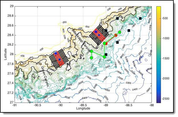
The project’s glider missions will involve two gliders – one equipped to measure turbulence – patrolling between two moorings (stars) for 1-2 months. A 12×12 grid of High Resolution Profiler (HRP3) stations will also collect CTD and oceanic velocity data for two weeks. Three field programs will be conducted, one occurring each year of the grant. Moorings (black squares), tracer injection (green dots), an initial sampling (red dots) from the previous study are also shown. (Image by the WHOI Advanced Engineering Lab)
The active environment of the Gulf of Mexico’s continental slope contains diverse currents that are difficult to simulate and predict.
We know that turbulence is an essential mechanism for hydrocarbon transport and subsurface oil plume dispersion, but we still have much to learn about the complex processes behind this area’s diverse currents.
The Gulf of Mexico Research Initiative recently awarded Dr. Kurt Polzin a grant to study turbulent ocean mixing over the continental slope and its relationship to oil and contaminant dispersion.
His team hopes to quantify the area’s turbulent processes and assess their spatial and temporal variability in response to various environmental and topographical factors.
“Our project is motivated by results from a previous tracer release experiment funded by GoMRI,” explained Polzin. “Tracer data collected from the Gulf of Mexico continental slope at approximately the depth of theDeepwater Horizon blowout revealed unusually intense vertical turbulent mixing. However, none of the simultaneously collected acoustic and oceanographic data could justify the pattern of tracer concentration.”
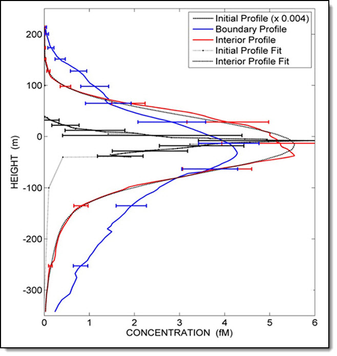
Initial (solid black) and four-month mean boundary layer (blue) and interior layer (red) vertical profiles taken from the initial tracer release. Concentration refers to the concentration of tracer compounds at a specified height. The large tails of the boundary profile indicates greater mixing at the boundary layer. (Ledwell, et. al., 2016; Provided by Kurt Polzin)
The team will directly observe turbulent mixing using an integrated, multi-platform field effort. State-of-the-art turbulence platforms and sensor systems will provide a four-dimensional characterization of turbulent mixing that spans the entire water column.
The researchers will conduct a two-week spatial survey and several two-month glider surveys focusing on two regions with distinct topographic structures.
Using measurements from over 144 stations, the team will quantify topographical patterns and local environmental and hydrographic variables. Gliders will capture the features of dynamic deepwater currents identified in the study area.
The scientists hope their research will expand our understanding of vertical turbulent dispersion and help improve the representation of mixing processes in modern plume dispersal models. They hypothesize that the enhanced turbulence resulted from nonlinear phenomena such as hydraulic effects and sporadic flows over the continental slope’s complex topography.
“There is much about these processes that we don’t understand,” said Polzin. “There are meaty science questions here, as rotation is a fundamental oceanic issue but atmospheric research deals almost completely with non-rotating approximations.”
This clip (above) depicts a 3D visualization of the tracer that sparked Polzin’s current project as it moved through the northern Gulf’s complex deepwater topography. The tracer and its accompanying RAFOS float (whose path is marked by the smaller blue and black dots) were injected at about 1100 meters depth above the 1250 m contour (thin blue lines). When Hurricane Isaac (large black dots appearing at 0:12) passed rapidly through the moored array (thick vertical black lines), it caused the float to move upslope, downslope, and westward more rapidly and chaotically, transporting it over a ridge as well as into the seafloor (puffs of smoke). (Video by Kurt Polzin and Jack Cook)The project’s researchers are Kurt Polzin and John Toole at the Woods Hole Oceanographic Institute, Steven DiMarco at the Texas A&M University Department of Oceanography, and Zhankun Wang at the Texas A&M University Geochemical and Environmental Research Group.
************
The Gulf of Mexico Research Initiative (GoMRI) is a 10-year independent research program established to study the effect, and the potential associated impact, of hydrocarbon releases on the environment and public health, as well as to develop improved spill mitigation, oil detection, characterization and remediation technologies. An independent and academic 20-member Research Board makes the funding and research direction decisions to ensure the intellectual quality, effectiveness and academic independence of the GoMRI research. All research data, findings and publications will be made publicly available. The program was established through a $500 million financial commitment from BP. For more information, visit http://gulfresearchinitiative.org/.