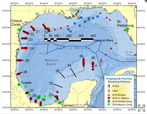
The cruise map of the One Gulf Expedition shows the 69 long-line stations (red circles) completed in 40 days. Researchers caught over 2,400 fish to study the impacts of Gulf oil spills. (Credit: C-IMAGE Consortium)
An international science team recently completed a 4,000-mile expedition to learn more about the long-term fate of two of the world’s largest subsea oil spills, the 1979 Ixtoc-I and the 2010 Deepwater Horizon. The 40-day Gulf of Mexico voyage continued their 2015 field campaign, contributing to a multi-year Gulf-wide analysis of these oil spills and the marine environment’s response and recovery.
Aboard the R/V Weatherbird-II, researchers with the Center for the Integrated Modeling and Analysis of Gulf Ecosystems II (C-IMAGE II) collected thousands of bottom-dwelling fish, sediment, water, and plankton samples from the Yucatan Peninsula and Bay of Campeche to the Texas shelf. A land-based team combed Mexico’s Campeche, Tabasco, and Veracruz shorelines for evidence of residual oil.
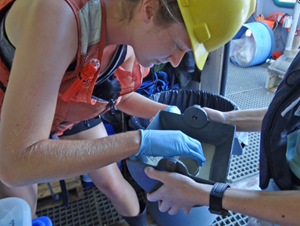
Erika Fredrik (USF) collects deep-sea sediment samples used for microbial studies with GoMRI partners. (Credit: C-IMAGE Consortium)
“It’s unprecedented to undertake this type of research,” said University of South Florida (USF) Professor and C-IMAGE Director Steven Murawski. “Planning logistics, acquiring permits, and organizing resources needed for 40 days at sea in international waters is very difficult; and we appreciate the many agencies and groups that helped make this expedition possible.”
The samples collected during the 2015-2016 expeditions contributed to the first set of Gulf-wide baseline data, enabling scientists to characterize the Gulf’s present condition. Analyses of biota and sediment will help identify if there are relatively pristine (oil-free) areas of the Gulf and inform impact assessments of future spills.
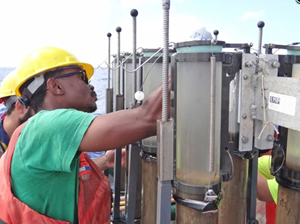
Ph.D. student Usman Muhammed (ETH-Zürich) transfers a core of Gulf sediments into storage for future chemical analysis. (Credit: Benjamin Prueitt, C-IMAGE)
A significant challenge in assessing Deepwater Horizon impacts is not knowing contamination levels before the spill. One way that the OneGulf scientists are addressing the lack of pre-2010 spill data is to study areas impacted by Ixtoc-I and forecast what Deepwater Horizon-impacted sites may experience in 30 years. “We hope to be able to fully characterize oil residue still remaining along the Mexican coasts,” said USF Marine Geochemist and team lead Patrick Schwing. “The samples we collected will help us identify the spatial extent, thickness, and any lasting impacts and study the products of this oil’s natural weathering.”
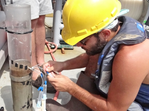
Dan Razionale, an undergraduate student at Eckerd College, collects pore water from a sediment core to test for levels of nutrients and trace metals. (Credit: Benjamin Prueitt, C-IMAGE)
The OneGulf team, however, did not start from zero to investigate the Ixtoc-I spill. Endowed Chair of Biodiversity and Conservation Science and Professor Emeritus John Wes Tunnell at the Harte Research Institute was studying corals off the Texas coast when the Ixtoc-I spill began. He documented where oil washed ashore and, even though funds ran out, continued taking students back to oil-impacted areas for years afterward. He guided the C-IMAGE researchers to the same locations that he had been monitoring. Tunnell and researchers with the Universidad Nacional Autónoma de México (UNAM) Adolfo Gracia and Elva Escobar-Briones played vital roles in designing studies to examine Ixtoc-I impacts.
The Ixtoc-I and Deepwater Horizon spills share many similarities and present a unique opportunity for comparative analysis. Here are some topics that the team hopes to learn more about:
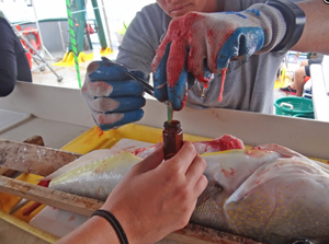
Researchers collect fish bile samples for toxicity analysis. Bile indicates how fish are metabolizing remaining oil levels. (Credit: C-IMAGE Consortium)
A Similar Marine Snow Event?
Recent studies (Passow, 2014; Brooks, et al., 2015; Hastings, et al., 2015) reported evidence that marine snow associated with Deepwater Horizon created a mechanism for oiled particles to reach the seafloor, which may serve as long-term storage for contaminants that could potentially reenter the water column (Chanton, et al., 2015). One question scientists have is: how long will sedimented oily particles remain in the environment, potentially affecting bottom-dwelling fish and sediment-dwelling organisms?
Researchers on the OneGulf voyage think they may have uncovered a clue. They found a layer of oily sediment buried under the seafloor near the Ixtoc-I site. Lab analyses of these sediment core samples will determine a possible source of this oily layer, and if the oil signature is consistent with an Ixtoc-I spill point source, then the answer may be possibly decades.
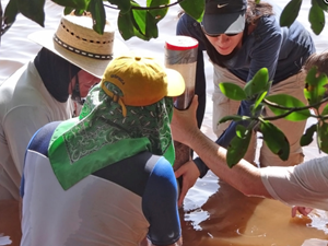
Researchers on the Tunnell Trek collect a sediment core adjacent to a mangrove forest impacted by the 1979 Ixtoc I spill. (Credit: C-IMAGE Consortium)
Food Web Impacts?
Ongoing investigations are addressing questions about short- and long-term impacts on the marine food web following the Deepwater Horizon spill. Recent studies (Murawski, et al., 2014; Synder, et al., 2015 and Tarnecki, et al., 2015; Wilson, et al., 2015) suggest that hydrocarbons associated with Deepwater Horizon may have entered the coastal food web; that some demersal fishes in oil-contaminated waters exhibited elevated hydrocarbon concentrations and experienced shifts in diet and trophic level; and that there was a short-term increase in observed fish lesions that declined as hydrocarbon concentrations decreased.
OneGulf researchers will compare tissues, blood, and bile from bottom-dwelling fish caught off the Veracruz coast, the most likely place where Ixtoc-I oil settled, to biological samples collected near the Deepwater Horizon site and unpolluted areas. They will use these data to establish if fish experience elevated hydrocarbon levels or lasting effects of exposure in the entire Gulf or just near Deepwater Horizon and Ixtoc-I sites.
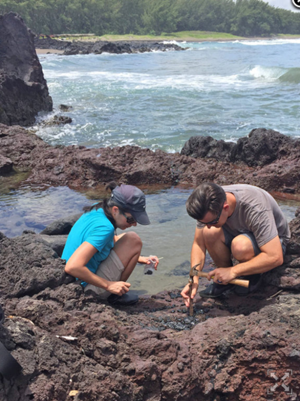
Isabel Romero and Patrick Schwing chisel a tar patty in Montepio, Mexico. Submerged tar still gives off surface oil sheens in tide pools along the shore. (Credit: Ethan Goddard)
Long-Term Shoreline Contamination?
Some of the most visible evidence of Deepwater Horizon contamination was weathered oil found in beached tar balls and sand patties (Aeppli, et al., 2012), oil buried in sand (Hayworth, et al., 2015; Yin, et al, 2015; Zuijdgeest and Huettell, 2012), and fouled vegetation (Judy, et al., 2014). How long will hydrocarbons from this weathered oil persist in and possibly harm northern Gulf coastal environments?
Another clue for answers may come from the OneGulf voyage. The land-based team found oily tar balls and slabs on beaches and in barren mangrove areas along Campeche, Tabasco, and Veracruz shorelines that they believe may be potentially from Ixtoc-I. Analyses of these recent collections is ongoing, and the team hopes the results will help provide insights about possible long-term coastal contamination and impacts from Deepwater Horizon.
What’s Next?
In one sense the cruise is over, but in another sense it is just beginning. Murawski explained, “The really hard work of cataloging, analyzing, and interpreting the significance of these results has just started.” Dozens of scientists and technicians from Europe, Mexico, Canada, and the United States will spend years refining our understanding of how the Gulf works and how subsea oil spills impact its large and diverse ecosystem.
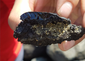
A piece of tar and asphalt found on Mexican shores. The tar layered some of the beach sands and still smelled of oil when broken. Future analysis will determine the lasting decadal effects of tar on the shores and in the mangroves. (Credit: Isabel Romero)
Scientists studying other important Gulf of Mexico issues are benefiting from the OneGulf expedition, too. The C-IMAGE team collected surface water samples for the Florida Fish and Wildlife Conservation Commission’s Harmful Algal Bloom group who are studying the diversity and spread of Gulf blooms including Red Tide (K.brevis). Two international Ph.D. students joined the voyage, Usman Muhammed with the Technical Institute of Zürich (ETH-Zürich) who studies carbon cycling and Diana Torres Galindez with the UNAM who studies deep-sea fishes. An official from the Mexican fishery service, INAPESCA, assisted the C-IMAGE efforts and collected offshore shark species samples.
“We have learned a great deal about the Gulf’s health after the Deepwater Horizon spill,” Murawski said. “But we can’t stop here. There’s remarkable scientific potential in the southern Gulf as well.”
More Information:
- Listen to a podcast Ixtoc Spill: Reflections featuring scientists Wes Tunnell and John Farrington.
- Listen to a podcast In the Mud in Mexico featuring scientist David Hollander
- Read updates and see pictures from those who participated in this summer’s expedition at #OneGulf and the C-IMAGE blog and Flickr site.
************
This research was made possible in part by a grant from the Gulf of Mexico Research Initiative (GoMRI) to the Center for the Integrated Modeling and Analysis of Gulf Ecosystems II (C-IMAGE II).
The Gulf of Mexico Research Initiative (GoMRI) is a 10-year independent research program established to study the effect, and the potential associated impact, of hydrocarbon releases on the environment and public health, as well as to develop improved spill mitigation, oil detection, characterization and remediation technologies. An independent and academic 20-member Research Board makes the funding and research direction decisions to ensure the intellectual quality, effectiveness and academic independence of the GoMRI research. All research data, findings and publications will be made publicly available. The program was established through a $500 million financial commitment from BP. For more information, visit http://gulfresearchinitiative.org/.